by Lia Nigro
Freelance Writer based in Columbia, Maryland
The Route 1 Corridor has seen a lot of plans over the years. Its 12 miles are home to approximately 15 percent of Howard County’s residents and 30 percent of county jobs, but residents complain of a lack of amenities from good restaurants to safe sidewalks and a zoning hodgepodge of industrial eyesores and cheap motels. Change is desired and has long been pursued but has proved hard to achieve.
Current planning efforts were highlighted at a public meeting June 27 at the North Laurel Community Center. Representatives from the Howard County Department of Planning and Zoning and their consultants RKG Associates Inc. spoke to a small and somewhat disgruntled group of area residents. Peter Conrad, Deputy Director of the Department of Planning and Zoning acknowledged their concerns and the challenges the area presents, describing it as “a complicated corridor.”
The Planning and Zoning department has reached the midway point in creation of a Master Plan for the corridor, with RKG Associates having completed an approximately $300,000 study encompassing needs, opportunities, and recommendations. The Route 1 Master Plan is expected to be finalized in the fall, then published as an amendment to the Howard County General Plan update, which in turn is expected to be completed in eighteen months to two years and to provide a document to guide new zoning regulation and other county action.
The RKG Associates study centers on land use and transportation analysis. The consultants started by gathering community input through a series of “Project Open Houses” and an online “Virtual Open House” survey, with over 1,300 comments from more than 200 participants collected.
In putting together a plan that responds to the community’s identified needs, “We’ve identified what could happen,” said RKG Associates Vice President and Principal Russell A. Archambault. “We’re not saying this is the direction you’ll ultimately go.”
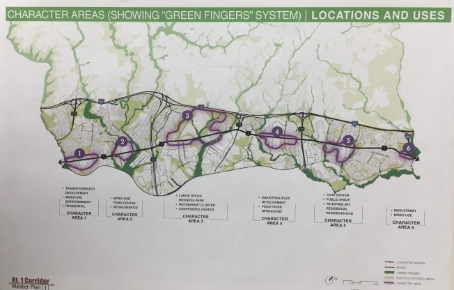
Relating to land use, a decision was made to focus on six key “Character Areas” comprising perhaps a quarter of the length of the corridor. “You can have an impact in these areas. It’s very difficult to have an impact over twelve miles; there’s not enough money for it,”said Archambault. Instead “you choose areas for catalytic development,” where action may trigger change in other parts of the corridor.
The plan map was titled “Green Fingers,” reflecting desire to better integrate the green spaces and natural areas along the corridor.
The areas chosen for the plan and recommendations for how land use in each of these areas might be optimized is summarized here:
Character Area 1: County Line to Whiskey Bottom Road. “A small area but important as a gateway to the county,” commented Archambault. “It has the feel of sort of a Main Street environment, or could be that in the future.” Plan is for mixed use and entertainment, building on planned transit-oriented development of Laurel Park.
Character Area 2: Hammond Branch to Gorman Road. Mixed use town center. Shopping including a grocery anchor to serve surrounding residential areas. Public plazas, public art. Connections to Savage Mill Trail and other surrounding green spaces. Compatible light industry.
Character Area 3: Quarry to Assateague Drive. “A longer term play” as quarrying is completed in perhaps 10 to 20 years. Business/office park. High quality office buildings. Multiple hotel sites, conference center, restaurants integrated with stream corridors and natural resource areas. Public space with plazas.
Character Area 4: Blue Stream Drive to Route 100, described by Archambault as “the bread and butter of Route 1.” Light industrial, appropriate to context (one-story with garages behind). Flex office space, showrooms. Formal area for variety of food trucks with public art celebrating corridor’s industrial (distribution) character.
Character Area 5: Use activity generated by new library to establish a civic node, with signature buildings in a walkable, campus-like setting. Indoor and outdoor recreation spaces, low to medium density residential connected to trails and multi-use paths.
Character Area 6: Old Washington Road to Main Street. Could become “a more complete Main Street” with changes in a few sites. Mom-and-pop stores, restaurants, civic area with focus on education, easily accessible parks/open space. Retain special places.
For transportation, the plan will set near-term goals (priority and easy options, for instance, closing sidewalk gaps near the MARC station); mid-term goals (emphasizing broader safety for all users including pedestrians and bicyclists); and long-term (perhaps redefining lane width and lowering speeds for some parts of Route 1).
While the planners explained how some parts of Route 1 are “over designed” with lanes wider than called for by volume, and that such circumstances encourage speeding, the audience did not appear convinced that lane size should be reduced. “I haven’t seen any narrow tractor trailer trucks yet,” commented one man.
Including the Route 1 Master Plan as a General Plan amendment gains the content added weight and consideration. The next step, as the county moves forward on zoning changes and other steps supporting the amendment, might be to establish a nonprofit partnership/holding company to bring together stakeholders and direct efforts.
The county might also establish a “Route 1 Land Bank” holding company to acquire key sites as they came on the market and require re-purchasers to meet plan requirements, something that has succeeded in other states. The “missing piece” of who’s responsible for leading the effort, not addressed in past studies, needs to be addressed,” concluded Archambault.
A second challenge, “the hardest part,” is funding. Options such as taxation, “a dirty word I understand,”said Archambault, “cannot be dismissed” without consideration; for instance a surtax on state sales tax is a practice that had worked for similar efforts in other southern states, though not currently an option in Maryland. “We need a dedicated source of funding.”
At the conclusion of the Route 1 Master Plan presentation, the audience asked numerous questions. A range of problems were brought up, from human trafficking to drainage issues and flooding following the construction of new developments. “I want you to go to a County Council meeting,” summed up one woman, “I want you to go to [County Executive] Calvin Ball, and I want you to vent to them the way we’ve vented to you tonight.”
Conrad expressed his desire to push forward the work done so far, and to expand it. “This is a plan that is trying to turn the wheel and get us collaboratively to go in a new direction,” he said. “Really we have a need to get your feedback and your comments at this level so the plan reflects your visions and your input.”
The presentation given at the June 27 public meeting and the accompanying displays are expected to be posted on Howard County’s Route 1 Master Plan Web site in the next week or so. This page already provides a great deal of background on the plan as well as contact information for Peter Conrad, and it will continue to trace the Master Plan’s progress as it moves forward.